Sunday, August 5, 2012

Lake Louise Hiking: Lake Agnes Trail

Lake Louise - Banff National Park, Alberta, Canada
Lake Louise - Banff National Park, Alberta, Canada (Photo credit: Wikipedia)
English: Lake Agnes near Lake Louise in Banff ...
English: Lake Agnes near Lake Louise in Banff National Park, Canada. Mount Whyte (2,983 m) is the peak at top centre. The tip of Mount Niblock (2,976 m) can be seen at the top right. (Photo credit: Wikipedia)
Lake Agnes Trail:

Our hike yesterday was another unbelievable experience. While we could have done without the traffic on Highway 1, the lineup of vehicles at the entry way to Banff National Park and then the copious amounts of tourists and locals at Lake Louise itself. We did manage to find a parking place at a lot down the hill leading to the Chateau Lake Louise and then commenced an absolutely brilliant day.

We finished it off with a short sideline trip into Banff on the way back with supper at Eddie Burger.

High tea amid high peaks

Length: 3.5 km (2.2 mi) one way
Elevation gain: 400 m (1,300 ft)
Walking time: 1 to 1.5 hours one way
Starting point: In front of the Chateau Lake Louise
Origin of the name: Lady Susan Agnes MacDonald, wife of Canada’s first Prime Minister

"Lake Agnes is hidden in a hanging valley high above Lake Louise. In addition to its own charms, which include a teahouse, the two Beehives provide breathtaking views of Lake Louise and a broad stretch of the Bow Valley.

As you walk along the shoreline of Lake Louise, the trail to Lake Agnes branches right just beyond the hotel, then climbs steadily through dense subalpine forest. After 1.7 kilometres (1.1 miles), the first switchback marks a break in the trees where you have a clear view down to the pale turquoise water of Lake Louise. Another one kilometre (0.6 miles) of forest-enclosedclimbing brings you to Mirror Lake, a tiny lake with dark, layered cliffs of the Big Beehive looming above."

***
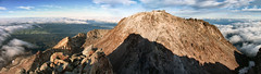
We also took up the option of Little Beehive for some spectacular extra views and much less trail traffic.

Options: "The most popular short hike beyond Lake Agnes is to Little Beehive,which provides an excellent panorama of the Bow River stretching from the mountains near its headwaters to surrounding peaks around the town of Banff to the south. Between Lake Agnes and Little Beehive are a number of rocky viewpoints overlooking Lake Louise, the hanging valley containing Lake Agnes, and Mount Aberdeen and the glacier-crowned peaks of Mounts Lefroy and Victoria. This 0.9-kilometre (0.6-mile) trail branches uphill from the shore of Lake Agnes just beyond the teahouse."

For more info:

http://www.summerthought.com/banff.hiking.lake.agnes.htm

http://www.lakeagnesteahouse.com/
Enhanced by Zemanta

Karst Spring - Kananaskis Country - Hiking Alberta

English: Canmore, Alberta, Canada, seen from t...
English: Canmore, Alberta, Canada, seen from the Ha Ling peak (Photo credit: Wikipedia)
mount egmont's summit viewed from the sharks tooth
mount egmont's summit viewed from the sharks tooth (Photo credit: dcysurfer / Dave Young)
Karst Spring - Kananaskis Country - Hiking Alberta:

Our hike today - another fantastic day in the Rockies. It was a beautiful summer day. After the hike, we drove back to Canmore for some poutine at La Belle Potate.

Karst Spring Hiking Trail

Difficulty Rating: Light
Distance: 9.5 km return. Elevation gain: 200 metres. Time: 3 1/2 hours return.
Location: From Canmore, drive 39 km south on the Smith-Dorrien / Spray Trail (Highway 742 - gravel road) which begins just past the Canmore Nordic Gentre.
Turn right 5 km. to the Mount Shark parking lot, where you will find the trailhead.
Description: This trail leads to Karst Spring where boulders and driftwood are covered with bright green moss. The gentle elevation gain makes this hike a favorite with families, and the cool air near Karst Spring is appreciated hot summer days. The first 3.6 km. are open to bicycles. Walking on the road leads you through the Mount Shark Trail System into the forest above Watridge Lake where a short descent puts you at the shore of this lake known for it's trout fishing (don't forget your licence). Then follow the boardwalk and climb the trail along the creek to where Karst Spring bursts out of a rock face. The spring drains from passageways between limestone layers of Shark Ridge creating a karst formation. Snow and rain water seep into cracks and dissolve the rock, creating tunnels from which streams begin.

***

From Hiking With Barry:

"This short and beautiful day hike is about 9 KM round trip with gentle elevation.  In winter it is a snowshoe trip on decent, narrow trail through predominantly aromatic, evergreen forest.  From Calgary, the drive is west on the TransCanada, south on Kananaskis Trail (Hwy 40), to the gated end, then briefly west for a right turn north onto Smith-Dorrien and the left hand exit past the historic and rustic Mount Engadine Lodge.  The trailhead is at the Mount Shark parking lot at the end of the drive up this road.  This Mount Shark area contains a labyrinth of professionally groomed, cross-country ski trails.  The site was developed and used for training and overflow events during the 1988 Winter Olympics hosted by Calgary.  The primary cross-country ski venue was the Nordic Ski Centre in Canmore, Alberta.  Both are well maintained world-class skiing opportunities."

***
More info: http://hikealberta.com/hike/karst-spring-hiking-trail
Enhanced by Zemanta

LinkWithin

Related Posts Plugin for WordPress, Blogger...